Krovanh storm strikes Vietnam’s southernmost province
Krovanh storm is moving southwest to the cape of Ca Mau, the southernmost point of Vietnam.
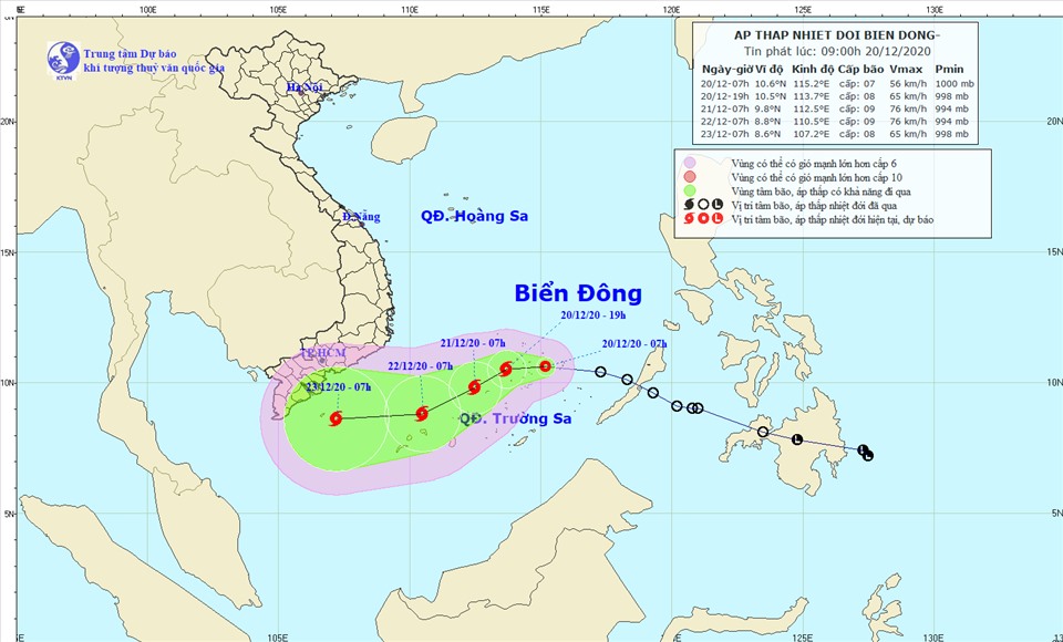
A tropical depression in the East Sea has intensified into Krovanh storm and is moving towards Vietnam’s southernmost province of Ca Mau, according to the National Center for Hydro-Meteorological Forecasting (NCHMF).
It has become the 14th typhoon of the year to enter the East Sea, known globally as the South China Sea.
Krovanh was located 120 km (74 miles) south of Vietnam's Truong Sa (Spratly Islands) with strongest wind speeds of 60-75 kilometers per hour (kph) as of December 20, the NCHMF said.
In the next 24 hours, it is likely to move towards the west and then south-west at 10-15kph and grow stronger, the center added.
The direction of Krovanh storm. Photo: NCHMF |

At 1:00pm on December 21, the eye of the storm will be about 330km southwest of the Truong Sa Archipelago. The strongest wind speeds in the area is predicted at 60-90 kph.
As of tonight, the storm will stand 180 km east northeast of Truong Sa. The strongest wind speeds in the area near the eye of the storm are predicted at 60-90 kph.
It is expected to keep moving in the same direction and weaken into a tropical depression on December 22.
During the next 48 to 72 hours, the storm will move mainly to the west with speeds of 10-15km per hour and weaken into a tropical depression.
By tomorrow afternoon, it is predicted to churn at around 270 kilometers from Con Dao Island before downgrading to a tropical low pressure system in the territorial waters off provinces from Soc Trang to Ca Mau.
Due to the impact of the storm, the middle and south- East Sea including the Spratly Islands will witness blustery winds and rough sea.
Japan’s weather forecast station has made a similar prediction, saying the storm is moving southwest to the cape of Ca Mau, the southernmost point of Vietnam.
Rough to very rough seas are expected over the middle and south areas of the East Sea with tides between 5-7m.
In order to respond to the Krovanh storm, Vietnam’s southern localities are advised to keep regular communication with boat owners, meanwhile rescue forces and equipment are ready to promptly handle possible situations.
Actions would be taken to ensure the safety of people and property including oil and gas platforms and economic activities at sea.